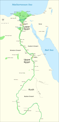
Lower Egypt (Arabic: الدلتا al-Diltā) is the northern-most section of Egypt. It refers to the fertile Nile Delta region, which stretches from the area between El-Aiyat and Zawyet Dahshur, south of modern-day Cairo, and the Mediterranean Sea.Today there are two principal channels that the Nile takes through the river's delta: one in the west at Rashid and one in the east at Damietta. In ancient times, Pliny the Elder (N.H. 5.11) said that upon reaching the delta the Nile split into seven branches (from east to west): the Pelusiac, the Tanitic, the Mendesian, the Phatnitic, the Sebennytic, the Bolbitine, and the Canopic. Today the delta region is well watered, crisscrossed by channels and canals.Lower Egypt was known as Ta-Mehu which means "land of papyrus." It was divided into twenty districts called nomes, the first of which was at el-Lisht. Because Lower Egyptwas mostly undeveloped scrubland, undeveloped for human life and filled with all types of plant life such as grasses and herbs, the organization of the nomes underwent several changes.The climate in Lower Egypt is milder than that of Upper Egypt owing primarily to its proximity to the Mediterranean Sea. Temperatures are less extreme and rainfall is more abundant.The capital of Lower Egypt was Memphis. Its patron Goddess was the cobra goddess Wadjet. Lower Egypt was represented by the Low Red Crown Deshret, and its symbols were the papyrus and the bee.From the late 19th century, Alexandriabecame a major centre of the international shipping industry and one of the most important trading


0 comments
Write Down Your Responses